
Possible Planting Area is an add-on available for your TreePlotter CANOPY application. The Possible Planting Area can be seen within the View Tool.
Possible Planting Area is the percentage of area available for tree planting within a selected geography.
Striving for Accuracy
Upon purchase of a TreePlotter CANOPY application with Possible Planting Area included, our Sales team will be in touch about any available unsuitable planting space data. Shapefiles containing sport fields, golf courses and any unsuitable planting spaces are helpful for us to calculate a more precise Possible Planting Area metric.
Data available from the National Aerial Imagery Program (NAIP) and any data available at your organization will be combined to calculate the Possible Planting Area. If data is not available at your organization, just National Aerial Imagery Program (NAIP) data will be used to calculate Possible Planting Area.
Any areas not included in your supplied data sets or the National Aerial Imagery Program (NAIP) dataset will be manually digitized and also used to calculate Possible Planting Area as well.
Understanding Possible Planting Area
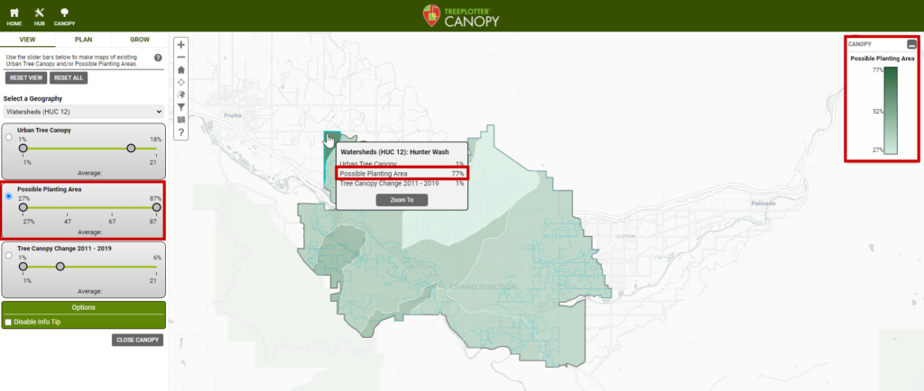
The Possible Planting Area can be found in the View Tool. Areas with higher Possible Planting Area consist of a higher percent of space available for planting trees.
Using the Legend in the top right corner of your screen, you will be able to see the range of percentages for available planting space in your area. Polygons on the map that are darker in color have a higher percent of Possible Planting Area.
By clicking on an area, you will see a pop up detailing the percent of Possible Planting space.
Using the slider bar in the View Tool, you can query for areas that have a specific range of percentages. The areas within the range specified will be the only ones shown on the map.
How Possible Planting Area is used
Possible Planting Area can be used as an initial guide to decision making when trying to determine which areas have the most space available for planting new trees. The Possible Planting Area is best used as a preliminary method for identifying plantable locations and further on-the-ground inspections will be needed.
It is important to note, the Possible Planting Area does not take societal factors such as Tree Equity Score, Average Temperature, or Vulnerable Populations into account. Therefore, the Possible Planting Area does not include which populations can benefit the most from tree planting. The Possible Planting Area is calculated using land use only.