
This tutorial overviews how to enable geolocation in the TreePlotter™ application as well as some common geolocation issues.
Topics covered in this tutorial:
- Geolocation Service Overview
- Geolocation Relevance
- Device Location Permissions
- Geolocation Navigation
- Map by GPS
- Global Navigation Satellite System (GNSS) Receivers
- Geolocation Issues
- Known Limitations
- Next Steps
Geolocation Service Overview
The TreePlotter application allows the user to find their approximate location using the location services of the device being used to map assets (e.g. trees) with the Map by GPS function. The location of the user is determined by your device exchanging information with satellites, the connection with mobile data networks, and the location of local Wi-Fi networks. A Global Navigation Satellite System (GNSS) receiver may be used in conjunction with the device to gain better location accuracy beyond the capability of the GPS chip.
The following sections will review the relevance of knowing the device location when plotting points, how to enable the geolocation service on your device, the Map by GPS function within TreePlotter, using a GNSS receiver, and common issues that may be encountered when working with geolocation services and GNSS receivers across various devices, browsers, and operating systems.
Geolocation Relevance
When mapping assets like trees — whose canopies tend to overlap in many urban settings — it can be difficult to know where to plot a point to delineate the asset simply by looking at the basemap for reference. For instance, trees may lean one way or another which can position their canopy in a space that doesn’t define where the tree is actually rooted (i.e. a tree planted in a curbside strip with the majority of the canopy leaning over private property). Thus, the geolocation service serves as an aid in determining where the device is geospatially located on the basemap so that a plotted point can accurately reflect the location of the asset. For example, the user can turn on the geolocation permissions on the device to find their location and then accurately plot points for assets while simultaneously viewing the location in real time. In addition, points can be plotted using the Map by GPS function.
Device Location Permissions
TreePlotter uses the geolocation service that is native to the device which is controlled by the device settings. Issue(s) may arise when using the Find my Location or Map by GPS function if there is limited connectivity (poor mobile signal or lack of WiFi) or if the location services on your device or browser have not been enabled. Where these services are found on different browsers and devices is outlined below.
Google Chrome: Settings -> Advanced -> Content Settings -> Location
Safari: Safari -> Preferences -> Privacy
iPad/iPhone: Settings -> Privacy -> Location Services
Android (may vary depending on exact device): Settings -> Security and Location -> Privacy -> Location
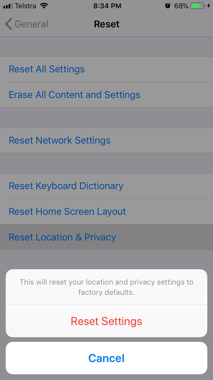
Note: If you are using an Apple product, you may also need to reset your Location and Privacy services. You can do this by going to Settings > General> Reset and selecting “Reset Location & Privacy”.
Geolocation Navigation
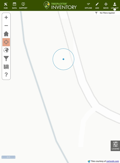
Once the geolocation settings on the device have been enabled, the geolocation service within TreePlotter can be enabled/disabled. to enable this service, navigate to the Toolbar in the upper left-hand corner of the screen and select the Find Your Location icon highlighted in the blue rectangle.

A blue dot will appear which shows the device location on the map. A blue circle will appear around the blue dot which indicates the uncertainty in the device location (i.e. the device may be located anywhere within the blue circle). The circle will also change size based on the uncertainty; a larger circle means the device location is more uncertain while a smaller circle means the device location is more certain.
Map by GPS

Each time the ‘ADD’ button is selected a pop-up window will display with two selections: 1) By Map or 2) By GPS.
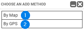
The By Map selection allows the user to place a point anywhere across the map surface without any constraints on where the point is placed. However, the By GPS selection allows the user to place a point that is constrained to the geolocation of the device. The geolocation of the device is limited to the capability of the GPS chip within the device. Location accuracy can be enhanced with the use of a GNSS receiver.
Global Navigation Satellite System (GNSS) Receivers
GNSS refers to any satellite constellation that provides positioning, navigation, and timing (PNT) services regionally and/or globally. A GNSS receiver refers to a ground-based device that communicates with the GNSS (i.e. GPS units). The receivers can be used in conjunction with TreePlotter software to enhance geolocation accuracy. Most receivers are battery powered units that mediate GNSS signals between the GNSS and TreePlotter software via a bluetooth connection with the collection device (e.g. tablet, phone, etc.). The receiver is paired with the collection device through a downloaded app specific to the receiver where the receiver will conduct a scan for the collection device to pair. Once paired, the receiver will begin generating positions based on the location of the device.
We have a downloadable PDF available here on what to consider if you are looking for a GNSS device.
Known Limitations
In some cases, the collection device may be undiscoverable even if the location settings are enable on the device and Find My Location is selected. This issue is most likely related to the JavaScript geolocation service which is the platform TreePlotter uses to obtain location information.