
The TreePlotter™ INVENTORY WFS is used for viewing the data in other GIS systems. This is a one-way sync of the data into the other system. The data will remain up to date until it is altered in that other system. Any alterations made to the data will not be live within TreePlotter after changes are made.
Topics covered in this tutorial:
- Typical Use Cases
- Using the Web Feature Service
- Instructions for the WFS and ArcGIS
- Rate Limit Information
- Known Limitations
Typical use cases for the WFS include developers using it to:
- Load data into ArcMap, QGIS, or another desktop application for analysis.
- Display map features from INVENTORY in your own web app, mobile app, or desktop app.
Using the Web Feature Service
Our Web Feature Service (WFS) from TreePlotter INVENTORY allows you to connect to your tree and other feature data using ArcGIS, QGIS, city management systems, and other map-based tools that allow loading a WFS layer.
- The folder name is after the forward slash in your URL, and can be found by applying the URL of your TreePlotter application to pg-cloud.com/foldername.
- The folder name should be in all lower case. Ex. tpDemo>tpdemo
- A Log-in within the Authentication is not needed when adding the WFS Server in Arc Pro.
The INVENTORY WFS is located at https://pg-cloud.com/api/wfs
For example, for the INVENTORY app at

https://pg-cloud.com/tpdemo

the WFS URL is

https://pg-cloud.com/api/wfs/tpdemo?apiKey=testkey
Instructions for the WFS and Esri Tools
IMPORTANT – for ArcGIS Pro, and ArcGIS Desktop with the Interoperability Extension, you must connect to the WFS by adding the Custom Parameter, doArcGISPaginationWorkaround=true.
When adding the WFS Server in ArcGIS Pro, the format of the connection should look like the image below: 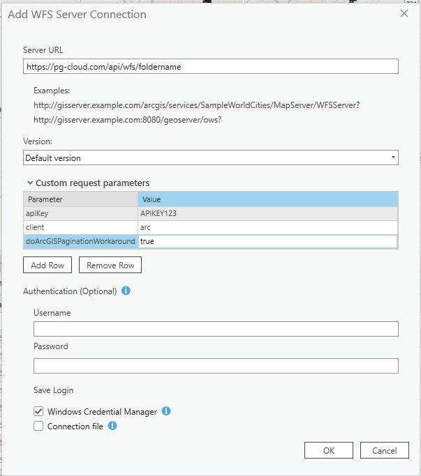
Rate Limit Information
All TreePlotter API endpoints (including WFS and REST services) use a rate limiter, with a rate limit of 5 requests per second, averaged over a 60 second window. Rate limiter information is included in the RateLimit HTTP response header.
If the rate limit is exceeded, further API requests will be returned with an HTTP 429 response code and a simple error message until the rate limiter resets. Your code will need to handle HTTP 429 responses and retry the original request a little later. We recommend you use an exponential backoff strategy.
Known Limitations
- Due to well-known limitations with ArcGIS WFS functionality, Arc products will not load all features for a layer with over about 3000 items. Our service delivers your large inventories as a series of links, which then can be loaded individually, one-at-a-time, and merged with the Merge tool.
- The TreePlotter WFS does not support connection with ArcGIS Online.